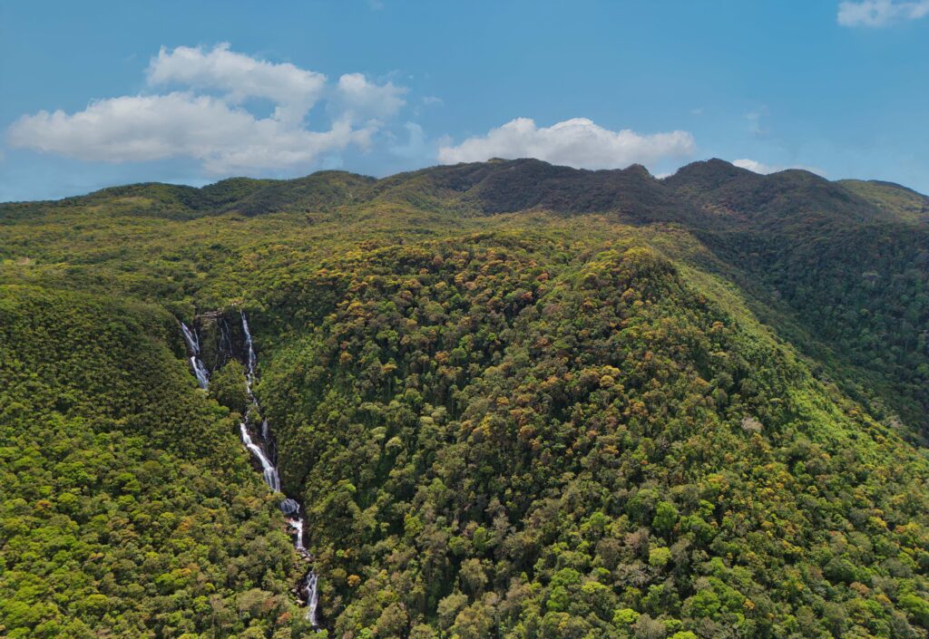
 Aerial view of the palm oil plantation (bottom of the photo) encroaching into Kanneliya rainforest, south-west of Sri Lanka. ©MONLAR Sri Lanka")
Speed Read:
- Unprotected forest patches around Sri Lanka’s Kanneliya rainforest, a globally recognized biodiversity hotspot, face ongoing deforestation.
- Despite a 2004 decision to absorb them into the country’s protected area network, delays have enabled continued forest clearance and degradation.
- An open-source intelligence (OSINT) investigation by CIR highlights how forest and tree cover loss occurred in five adjacent administrative areas from 2002 to 2024.
- One of South Asia’s most biodiverse and floristically rich lowland rainforests, Kanneliya is a critical catchment area for the Gin and Nilwala rivers.
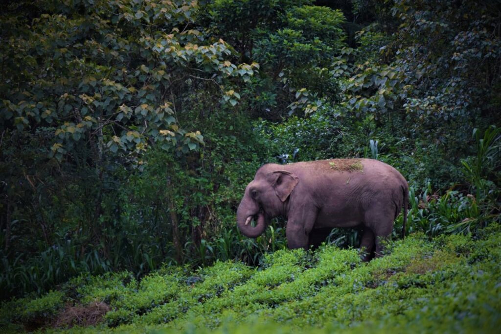
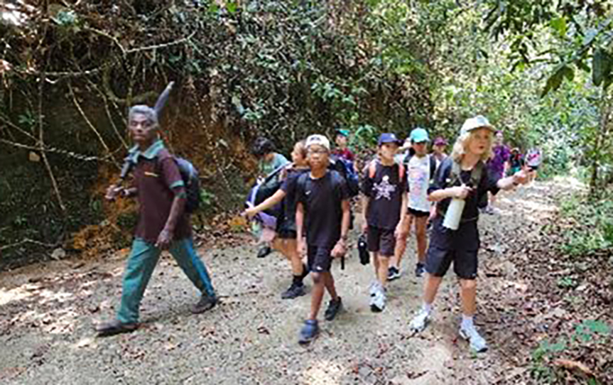
KANNELIYA, Sri Lanka— Seventy-four-year-old Gunadasa Pathirana is a senior wildlife guide in Kanneliya, a rainforest located in the southern district of Galle. Hailing from Koralegama, a village bordering the Kanneliya forest, Pathirana daily encounters a remarkable array of wild animals ranging from rare horned lizards (Ceratophora aspera) and endemic green pit vipers (Trimeresurus trigonocephalus) to vibrantly hued birds, but he continues to miss sighting his favourite animal: the elephant. (Elephas maximus maximus).
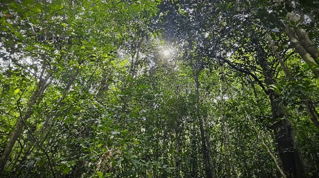
Spanning over 10,139 hectares (101.39km²), the Kanneliya forest reserve is a lowland rainforest recognized by UNESCO as a man and biosphere reserve for its exceptional biodiversity. Situated 35 km northwest of the city of Galle, Kanneliya serves as a major catchment area for Gin and Nilwala, two important rivers in the island’s south, and is home to many endemic plants and animals.
“This forest was once marked by the footprints of majestic elephants, but by now, Kanneliya has lost them all. There is a great sense of loss within me,” Pathirana says.
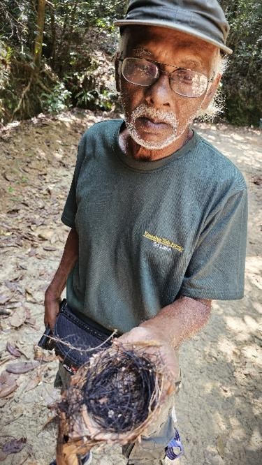
He recalls a time when herds of elephants roamed the forest. “I have seen at least three elephants feeding on paddy in a field near my home. In the mid-80s, I had this memorable moment late at night, watching their silhouettes move majestically in the soft moonlight, which was magical,” Pathirana reminisces.
Sadly, Kanneliya lost its last elephant in 1997, he says.
In the past, these forested landscapes were interconnected, allowing elephants to move freely between regions. Over time, those ecological corridors were severed, isolating the Kanneliya elephant herd and possibly leading to their disappearance from the wild, he says.
An ecosystem haven
Sri Lanka’s rainforests are among the most biologically rich ecosystems in South Asia, harbouring an extraordinary level of endemism within a relatively small island. Found mainly in the southwestern wet zone, these forests—including Sinharaja, Kanneliya, Dediyagala, and Nakiyadeniya—play a vital role in regulating rainfall, maintaining river catchments, and preventing soil erosion.
The Kanneliya–Dediyagala–Nakiyadeniya, collectively known as the KDN forest complex, is one of the last remaining large tracts of lowland tropical rainforest in the country outside the Sinharaja World Heritage Site.
Numerous ecological studies and historical analyses support the assertion that the Sinharaja forest reserve and the KDN forest complex were once part of a vast, contiguous expanse of tropical lowland rainforest that stretched across the wet zone of southwestern Sri Lanka.
“Ecology of Sinharaja Rain Forest and the forest dynamics plot in Sri Lanka’s Natural World Heritage Site,” co-authored by Savitri Gunatilleke, Nimal Gunatilleke, A.U.K. Ethugala, and Shameema Esufali, describes how some endemic tree families occur in both Sinharaja and the KDN forests, suggesting that these habitats were once ecologically continuous before fragmentations due to human activities.
Historical land use, particularly during the British colonial period, caused extensive deforestation for tea and rubber plantations, breaking this once-continuous rainforest belt into isolated forest blocks.
In “Sinharaja: A Rain Forest in Sri Lanka,” de Zoysa and Raheem (1990) note that continuous forest cover likely existed between Sinharaja and KDN less than 200 years ago, and traces of this former connectivity can still be seen in intermediate forest patches and river catchments.
Supported by the United Nations Educational, Scientific, and Cultural Organization (UNESCO) and the International Union for Conservation of Nature (IUCN), Sri Lanka has since recognized this ecological history and proposed the creation of biological corridors, which are stretches of habitats that connect isolated protected areas, allowing wildlife to migrate, forage, and disperse safely. Linking these isolated forest patches in biodiversity-rich lowland rainforests through reforestation and conservation initiatives is now central to long-term biodiversity planning efforts.
Declining forest cover
Over time, it is not just the elephants that went missing in Kanneliya.
There is evidence that Kanneliya, an ecologically, hydrologically, and socially significant lowland forest forming a part of the KDN forest complex, has experienced continuous deforestation.
This OSINT-led investigation draws on satellite-based forest monitoring data and geospatial analysis conducted through Global Forest Watch (GFW), EOSDA LandViewer, and QGIS to track deforestation over a period of 22 years.
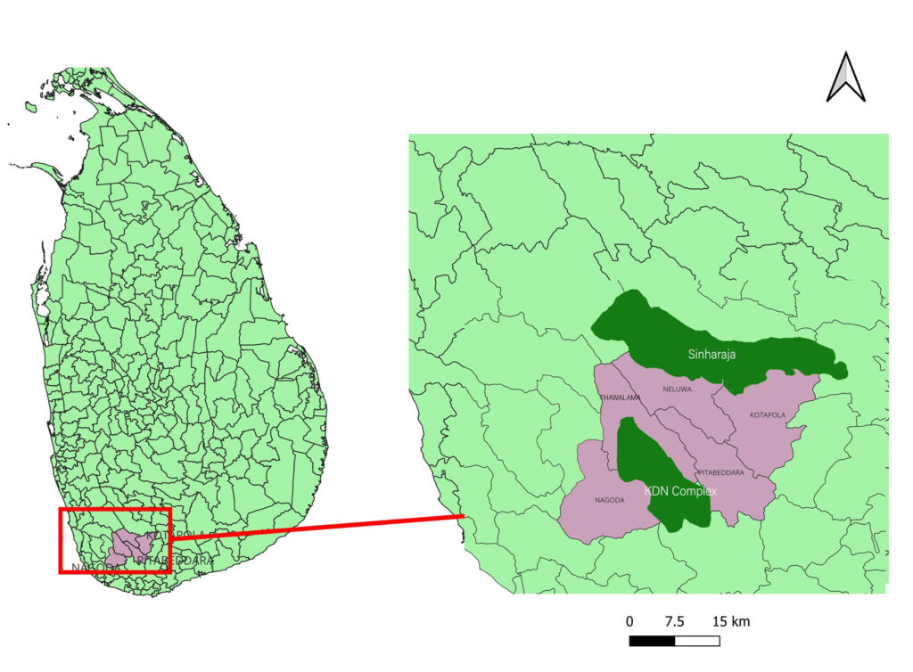
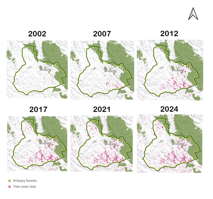
Global Forest Watch (GFW), a free online platform offering near real-time data on forest cover change, shows how five administrative areas that surround Sinharaja and KDN kept losing forest and tree cover.
Geospatial maps generated using the GFW data show how deforestation has taken place over the past two decades in these administrative divisions adjacent to the forest boundaries—Nagoda, Thawalama, and Neluwa in the Galle District and Kotapola and Pitabeddara in the Matara District.
GFW records tree cover through satellite imagery, capturing all woody vegetation above a defined height threshold—typically five meters or more. This includes natural forests, plantations, tree crops, and trees lying outside forested areas.
In contrast, forest cover, as defined in traditional forest assessments such as the Food and Agriculture Organization’s Forest Resources Assessment (FRA), combines tree presence with land-use category, requiring the area to be officially classified as forest and to meet specific ecological criteria.
This investigation offers a comparison of forest and tree cover loss during 2002-2024 across the selected areas and shows how vegetation decline varied from one area to another.
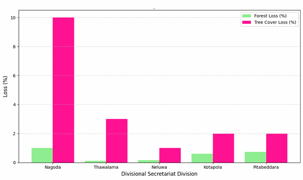
The Nagoda region recorded a 1% forest cover loss, while the area’s tree cover loss was as high as 10% during the same period, the highest among the five divisions. Data analysis shows significant tree removal outside the officially classified forests. Tree removal means the loss of trees in an area due to natural events such as storms and floods or human activities such as logging, farming, construction, and land clearing.
Nagoda covers a total land area of approximately 17,500 ha (175 km²). In 2000, approximately 91% of the land was covered by trees with a canopy density of over 30%. By 2001, about 14% of Nagoda’s total tree cover was classified as primary forest.
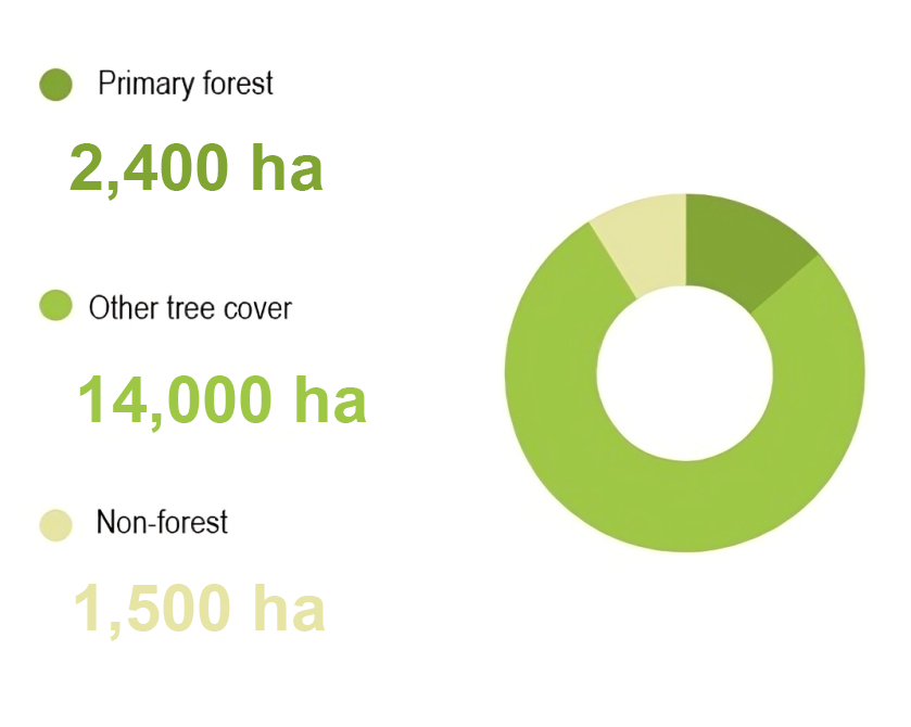
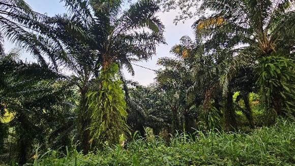
Data from 2002 to 2024 shows how oil palm has become the dominant plantation crop, spanning 3,400 ha (34 km²) and covering 20% of the total land area.
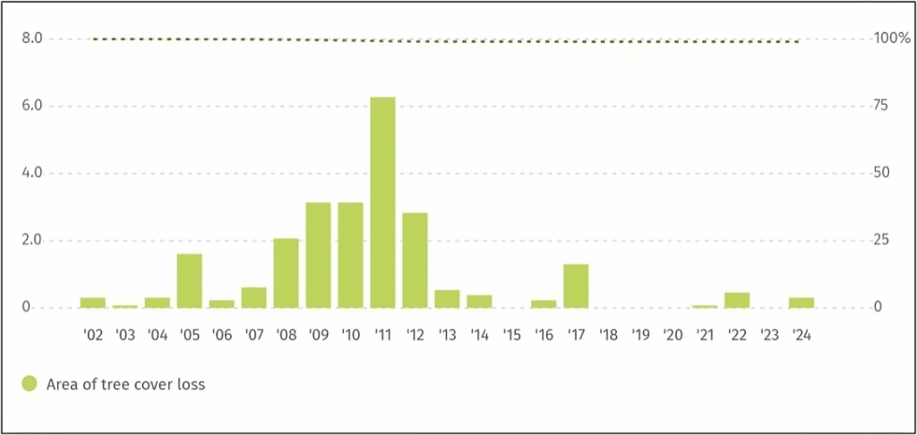
Nagoda has lost 24 hectares (0.24 km²) of humid primary forest during the 20 years, accounting for a 1.0% decline in forest cover. The loss of forests is not uniform across the years but shows a spike in specific years—from 2009 to 2012—with 2011 as the peak year.
Source: Global Forest Watch (GFW).
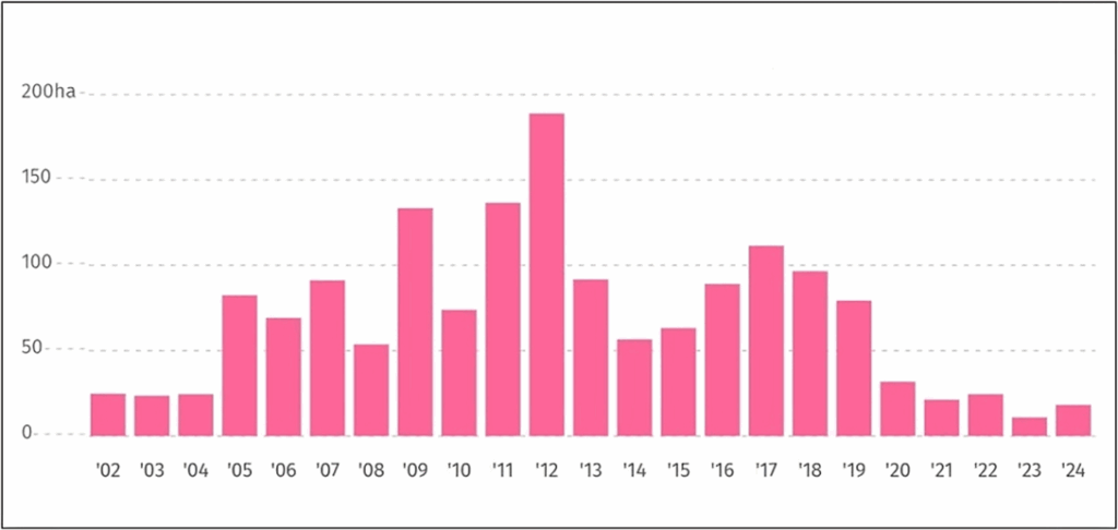
A temporal analysis between 2002 and 2024 shows that Nagoda has lost 1,600 ha (16 km²) of tree cover and about 10% tree cover by the year 2000.
Geospatial mapping also showed tree cover loss to be high around 2009, 2011, and 2012, with 2012 recording the highest loss.
Source: Global Forest Watch (GFW).
The following five-year interval map series illustrates the spatial pattern of tree cover loss from 2002 to 2024.
Source: Global Forest Watch (GFW).
A LandViewer analysis showed a spatially fragmented pattern of deforestation across the Nagoda landscape rather than large, continuous clear-cut areas.
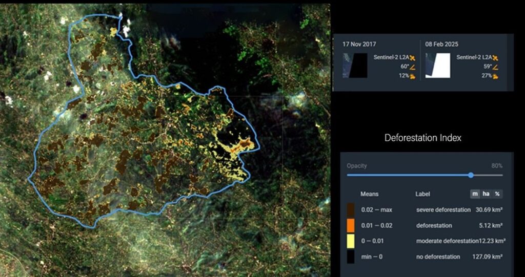
The deforestation index derived from Sentinel-2 L2A imagery (from 2017 to 2025) shows a clear quantitative pattern of forest disturbance across the Nagoda landscape covering approximately 17,500 ha (175 km²). Severe deforestation accounts for about 3,069 ha (30.69 km²), representing approximately 17.5% of the total area, and occurring in distinct, fragmented patches across the interior and edges of the landscape. The satellite images (from 2017 to 2025) show a clear pattern of forest loss in the Nagoda area, which covers about 17,500 ha (175 km²).
Severe deforestation is found around 3,069 ha (30.69 km²), making up about 17.5% of the total area. The forest loss appears in scattered and fragmented patches, both within the interior and along the edges of the landscape.
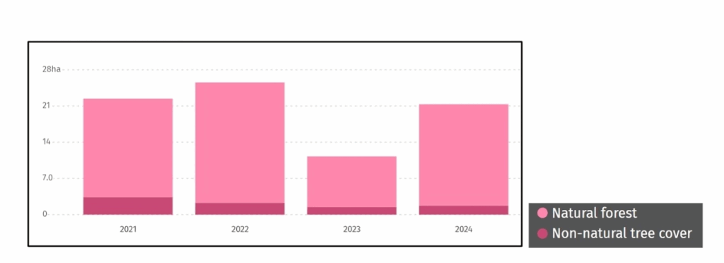
Alarming loss of natural forests
GFW’s updated indicators from 2021 to 2024 show an 89% tree cover loss in Nagoda within natural forests, totaling 72 ha (0.72 km²), reflecting fluctuating pressures on the region’s forest ecosystems.
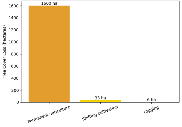
Drivers of tree cover loss
Further data analysis shows how Nagoda kept losing its tree cover, with logging, shifting cultivation practices, and permanent agricultural activities driving deforestation. Approximately 98% of total tree cover loss occurred in areas where these dominant drivers led to long-term land-use change.
Source: Global Forest Watch (GFW).
Nagoda’s deforestation was mainly driven by permanent agriculture, accounting for about 1,600 kha (16 km²) of tree cover loss, highlighting continuous conversion of forested land into agriculture. In contrast, temporary disturbances caused only minor losses, with shifting cultivation responsible for approximately 33 ha (0.33 km²) and logging for about 6 ha (0.06 km²).
GFW data highlights how permanent agriculture caused a continued deforestation pattern, resulting in irreversible forest conversion, rather than short-term or rotational land-use practices. In addition, GFW has another reason—forest fires—driving approximately 3 ha (0.03 km²) of total forest loss in the area.
Despite the GFW data showing the actual decline of forest and tree cover, government officials denied deforestation to be real. “There is no deforestation here,” U.V.A. Sarojani Sewwandi, Homadola village officer, told CIR. “Not to my knowledge,” she insisted.
Vishan Pushpamal is a conservationist who has been researching Kanneliya and its environs for over two decades. Before Kanneliya was recognized as a conservation forest, trees had been felled to supply timber to the State Timber Corporation. “This happened from 1968 to 1988. In 1990, Kanneliya was declared a forest reserve and, in 2004, a man and biosphere reserve, increasing its protection,” says Pushpamal.
When water runs dry
The ongoing deforestation has real consequences for the local people, and their main problem is water scarcity.
Every time there is a shortage, Selvi Veerani, 61, fetches drinking water in clay pots from a nearby well. “When it rains, we have water,” she says. “When there is no rain, we don’t have water, and we go in search of water.”
Veerani has lived in Udugama for nearly 40 years, a village bordering the Kanneliya forest reserve. She recalls a time when drinking water was not a luxury or tied to rainfall. “Back then, we had enough,” she said.
For generations, families living on the edges of Sri Lanka’s tea estates have traditionally drawn their drinking water from natural springs tucked within forest patches that have survived the expansion of colonial plantations.
The springs have sustained communities long before pipe-borne water schemes were introduced to the island and remain their main water source to date.
“But that delicate balance is under threat,” says Indi Akurugoda, a senior lecturer at the Department of Public Policy, University of Ruhuna, who studied Homadola, a locality bordering the Kanneliya forest, for her research, which delved into the expansion of commercial plantations and public agitation for water.
“These forests act as natural catchments, feeding springs that villagers rely on for their daily water supply. A conflict brewed when the estate administration suddenly started clearing the remaining forests to plant oil palm. Villagers wisely linked forest loss to the drying up of water sources. Public resistance emerged from the awareness that their survival was tied to these forests,” notes Akurugoda.
Need for conservation
Ranil Senanayake, a systems ecologist who established the concept of analog forestry in 1980, notes that between 1990 and 2010, Sri Lanka had lost an average of 24,500 ha (245 km²) – or 1.04%of its forests each year.
“This is about 20.9% of its forest cover, or around 417,000 ha (4,170km²). A forest contains a huge array of organisms that continually change in form and function. It is the biodiversity of a forest that signals its identity,” he says.
These small forest patches on many Sri Lankan landscapes usually represent the only habitat for rare indigenous or endangered species. “The ability of the areas presently scheduled or under protection is unable to provide habitats for all the species represented in Sri Lanka. This is due to the many different ecosystems arising from past geologic history that lie outside currently scheduled areas,” notes Senanayake.
Forests are not just repositories of biodiversity but are critical contributors to the atmospheric water reservoir. “Through the action of photosynthesis, 100 molecules of water are released for every molecule of carbon fixed. Sri Lanka’s forests contain about 61 million metric tons of carbon in living forest biomass, or about 6.1 million tons of photosynthetic biomass. The forests in Sri Lanka release over 600 million tons of water into the atmosphere annually, cleaned of impurities and contributing to rainfall over the island,” he says.
It is this hydrological activity of a forest and its capacity to contribute to and retain local rainfall that makes it so valuable, says Senanayake, adding, “With increasing climate insecurity, the water functions of a forest must be recognized as a critical national need.”
A unique home
The Kanneliya forest is home to a range of remarkable species and a biodiversity hotspot. “Sri Lanka is among the 36 global biodiversity hotspots due to high endemism in both plants and animals,” says Sandun Perera, who holds a PhD in environmental sciences and IUCN’s program coordinator.
“Much of the endemism is concentrated within the wet zone, approximately one quarter of the island. This includes the southwestern region and the entire central highlands. The eastern part of the central highlands forms an intermediate zone but is considered a relatively wet zone. The entire area, including the lowland wet zone, is therefore considered the crucible of endemism,” he explains.
According to conservationist Pushpamal, there are around 301 recorded plant species within Kanneliya. It is home to 41 species of reptiles, including four venomous species such as the Ceylon krait (Bungarus ceylonicus) and hump-nosed pit viper (Hypnale hypnale).
Around 58 bird species, 32 butterfly species, 18 mammals, and six out of 22 lizard species found in Sri Lanka can be spotted at Kanneliya. These include endemic species such as the hump snout lizard (Lyriocephalus scutatus), rough-nosed horned lizard (Ceratophora aspera), and Sri Lankan kangaroo lizard (Otocryptis wiegmanni), he notes.
Scientific studies show that Kanneliya forest reserve has exceptionally high plant species richness and diversity. Historically, this forest was much larger, extending all the way to Galle and also connected to the Sinharaja forest, he adds.
A wildlife in peril
Dinarzarde Raheem, a malacologist at Rajarata University, notes that many endemic species would have been driven to extinction well before extensive exploration of the Sri Lankan biota began in the 19th century.
“We do not really know because we have no data on species that were present prior to the colonial period,” says Raheem.
“The threats they face include not just decline in forest cover but also the degraded state of the forests in the northern wet lowlands. In the Udugama/Homadola area, as in other parts of the wet and intermediate zones, there are plantations where fields are periodically abandoned, sometimes for decades, and then recultivated, she adds.
Researcher Hiranya Sudasinghe, who extensively studies Sri Lanka’s freshwater fish ecology, says fish species such as the Wilpita rasbora (Rasbora wilpita), Jonklaas’s loach, or the spotted loach (Lepidocephalycthys jonklaasi), andthe slender rasbora, or panduwan halmal dadiya (Lepidocephalycthys jonklaasi), are threatened by deforestation in the area.
“Deforestation in upstream areas can negatively affect downstream protected habitats, as increased sedimentation and altered habitat quality degrade ecological conditions,” he tells CIR.
Meanwhile, conservationists argue that transferring ecologically important LRC forests to the Department of Forest Conservation would confer stronger legal protection and safeguard water catchments and biodiversity. “Forest cover in parts of the wet zone has rapidly vanished, putting locally endemic species at high risk,” adds Raheem of the Rajarata University.
Urgent challenges
“There are ongoing efforts to reclaim approximately 304 acres (3.04 km²) of land with vegetation similar to Kanneliya,” according to a forest officer connected to the Kanneliya reserve. Speaking on the condition of anonymity, he says, “This area was formerly an estate, but over time, portions were encroached upon or sold off. Some of these land issues date back to the 1970s. The Land Reform Commission (LRC) lacks documentation for some of these lands, which complicates the process of reclaiming land.”
A local activist who wishes to remain anonymous adds: “The forest has been gradually encroached upon through small-scale land grabbing.
Some of the remaining forests belong to private owners, but within these areas, large swathes of wilderness fall under the LRC. These forests are not automatically part of Sri Lanka’s formal protected area network, leaving them more vulnerable to development or changing land use.”
Jayantha Wijesinghe, chief coordinator of the Rainforest Protectors of Sri Lanka, tells CIR that over 2,500 ha (25 km²) of LRC lands adjoining the Sinharaja and the KDN forest complex have been identified as important forests decades ago, though there had been no move to include them within the formal protected area network yet.
Although this process began in 2004, delays have allowed nearly 405 ha (4.05 km²) of identified forest areas to be cleared, fragmenting habitats and threatening water sources and biodiversity. Irregular land use and questionable ownership claims have further accelerated environmental degradation in several estate areas bordering the forests, Wijesinghe tells CIR.
“Given the risk of irreversible damage, we urge the government to treat these acquisitions as an urgent national priority, ensuring coordinated and time-bound action,” adds Wijesinghe.
According to Chandima Palamakumbura, Conservator General of Forests, except for a few incidents, there is no rapid deforestation occurring in the wet zone.
“There’s more deforestation taking place in the dry zone,” says Palamakumbura.
The department has already demarcated boundaries in major forests in the wet zone. There are several small forest patches to be demarcated that have been adopted into the 2026 action plan, he adds.
Meanwhile, there are plans to acquire LRC lands adjacent to the Sinharaja and Knuckles forest reserves. “Some lands are natural forests, while others are plantations. The acquisition process is ongoing. But before that, they need to be surveyed, boundaries clearly demarcated, and private landowners spoken to about willingness to hand over lands. In some lands, boundaries are unclear,” he explains.
But conservationists claim that delays contribute to further deforestation. “For example, the order to protect Homadola Mukalana was given in the early 2000s. Two decades later, the forests are still being cleared,” says Hemantha Withanage, senior advisor to the Center for Environmental Justice (CEJ).
A silver lining
With attempts to increase protection and acquire LRC lands to create a necessary buffer, other efforts too are underway to protect the KDN forest complex.
The Endane Biodiversity Corridor by Dilmah Conservation was initiated in 2018 when the founder of Dilmah Tea, Merrill J. Fernando, symbolically removed some tea bushes in a strip of land on the Endane Estate to begin linking two fragmented forest reserves: the proposed Iharakanda forest reserve and the Walankanda forest reserve. The area is close to the Sinharaja rainforest reserve, which makes its ecological importance especially high.
“Protecting and reconnecting the fragmented Sinharaja landscape is critical to sustaining Sri Lanka’s rainforest biodiversity, as this connectivity strengthens genetic diversity, reduces local extinctions, and supports long-term ecosystem resilience,” says Nalaka Geekiyanage, co-lead scientist of the Endane Biodiversity Corridor project.
Highlighting the corridor’s significance, Geekiyanage explains the need to protect vital water catchments to help buffer communities against climate-related impacts such as floods and landslides.
The forest restoration must go beyond planting popular or fast-growing trees, instead prioritizing threatened native species that naturally occur in the area. Through dedicated nursery efforts, more than 120 locally threatened plant species are now being propagated to strengthen true ecological recovery of this biodiversity corridor, adds Geekiyanage.
Citations:
Akurugoda, Indi & Karunaratne, Manjula. (2023). Policy constraints in protecting natural water sources: A case study on people’s struggle to protect natural water sources in Homadola, Sri Lanka.
Gunatilleke, C. V. S., Gunatilleke, I. A. U. N., Ethugala, A. U. K., & Esufali, S. (2004). Ecology of Sinharaja Rain Forest and the Forest Dynamics Plot in Sri Lanka’s Natural World Heritage Site. Colombo: WHT Publications (Pvt.) Ltd.
De Zoysa, N., & Raheem, R. (1990). Sinharaja, a rain forest in Sri Lanka. Colombo, Sri Lanka. March for Conservation, University of Colombo.
Reporters: Malaka Rodrigo, Kamanthi Wickramasinghe and Ayodhya Kiriella
Additional Reporting: Aanya Wipulasena
Editor: Dilrukshi Handunnetti

